

In a videogame like KSP, with the click of a button you can determine your speed, orientation, and orbit; in real life, it’s not that simple. NASA has to rely on star trackers, Deep Space Networks, and a plethora of other tools to position their satellites in deep space, however as we go further out, these systems may not be enough. From exploring other planets, observing stars, and visiting asteroids, the whereabouts of a satellite is crucial for scientific advancement and human exploration.
There are 3 things a satellite needs to know:
Position: A satellite needs to know where it is relative to other things in our solar system to maneuver themselves correctly. Things like gravity assists or Mars landings wouldn’t be possible without knowing precisely where a satellite is.
Velocity: Satellites aren’t stationary so they need to know how fast they are going and the direction they are going. Going too fast could result in an overshoot and going too slow can result in a crash, so satellites need to ensure that they are in the goldilocks zone for velocity.
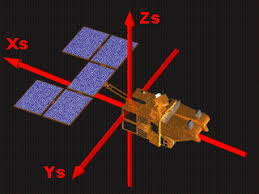
Attitude: This isn’t the same attitude you give to your boss when they ignore your emails, instead it’s the orientation a satellite. Although not as important as position or velocity, the orientation in space is needed for many things such as facing a target, docking, or maneuvering the satellite.
With this in mind, let’s dive into the current systems used by NASA, understand how they work, and point out any flaws they may have!
Radiometric Data
One of the most common ways a satellite positions itself is through the use of radio waves and there are many methods of doing it.
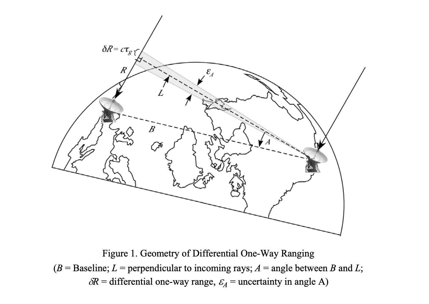
Delta-DOR
Delta DOR stands for Delta Differential One-Way Ranging and in essence, it uses multiple signals and ground stations to triangulate a satellite’s position. The satellite will transmit a signal to multiple different ground stations and the same time and by using the delay between broadcasting and receiving, the satellite can find it’s distance from each ground station. Using that information, it can triangulate it’s position in space.
GNSS
The Global Navigation Satellite System is a system of satellites in orbit around Earth that can transmit and receive precise radio signals. This system is used by GPS however it also works for other satellites as the GNSS satellites can send their position and time of broadcast to the satellite, which can use the info from multiple different GNSS satellites to triangulate it’s own position. The GNSS can use ground stations to position itself.

Doppler Shift
Doppler shift is a phenomenon that changes the frequency of a wave depending on the movement of the subject. This happens because when something is moving towards you, it compresses the waves and increases the frequency, however when something is moving away from you, it stretches the waves and decreases the frequency. This is why ambulance sirens sound higher pitched when moving towards you and why galaxies moving away from us emit more red wavelengths(The longest visible wavelength).

Tracking stations can leverage this by receiving signals from satellites and measuring the change in frequency due to doppler shift. using this, they can find the velocity of a distant satellite.
Problems with Radiometric Data
The main challenge that these systems face is latency, as although these signals are travelling at the speed of light, they still take time to be sent out and received. For example, a one way signal to Mars can take upwards of 22 minutes. In space, 22 minutes is a long time and it gives satellites an opportunity to drift into a completely different position.
These signals can suffer from background noise and interferences, making it difficult to interpret. Because space is so vast, there are many cosmic signals all around our solar systems that may interfere or damage signals between ground stations or GNSS and deep space satellites. Furthermore, ground stations must also account for weather conditions and the atmosphere, which can effect the signal or delay it.
Inaccuracies in onboard instruments can mess with these systems. All of these systems rely on timing however onboard clocks can drift out of sync with other clocks; this is made worse by the length of deep space missions, creating a larger drift. These inaccuracies can result in completely inaccurate positioning. Inaccuracies in Ephemeris data(positioning of celestial bodies) can also result in inaccurate positioning as satellites must know where the Earth is in order to communicate with it.
A problem specific to ground stations is the overcrowding of these networks, Specifically with the Deep Space Network. Each new mission into space requires hundreds of hours of communication time with the DSN and this results in it being overburdened with satellites to manage. The over 11000 satellites in space are overcrowding the underfunded DSN and it is making it more difficult to rely on radiometric data.
Vision Based Navigation
A lot of the issues with radiometric data comes from the fact that it is a 2 body system that requires both a broadcaster and a receiver. the use of cameras doesn’t require any of that as it is all in situ.
Star Trackers
A star tracker works by using onboard cameras to take images of the stars. Using these images, the satellite will identify patterns in the stars then cross reference it with a catalog of star patterns to determine its attitude.

Celestial Objects
Through the use of Ephemeris data, satellites can position themselves by identifying different celestial bodies and figuring out where these celestial bodies are. Using this info, the satellite can infer its own position by triangulating itself with the other celestial bodies.

Problems with Visual Systems
Storage: Star trackers rely on large catalogs of star patterns and as a result, take up a lot of storage. It also requires a lot of processing power to comb through every pattern. Other navigation systems require extensive ephemeris data and object recognition to position itself.
Camera Damage: Radiation, heat, and debris can damage camera lenses and sensors, leading to inaccuracies in positioning.
Random Interference: Unidentified celestial bodies and light pollution can interfere with a camera’s pattern recognition, ruining the positioning system.
Other Systems
Visual Navigation and Radiometric Data are the 2 most common positioning systems however there are many other ones such as magnetometers and Inertial Measurement Units.
Inertial Measurement Units
Some satellites come equipped with accelerometers and gyroscopes to keep track of their attitude and velocity. An accelerometer uses piezoelectric materials that generate electricity when under a force(Acceleration). A gyroscope uses angular momentum to orient itself upright and as a result, it can detect changes in attitude. By combining this information with ephemeris data, satellites can create a rough idea of where they are and where they’re going.

The problem with this system however is that it suffers from drift overtime as these internal sensors will slowly lose their precision. This means that satellites cannot rely solely on internal systems and require other systems to recalibrate its internal positioning.
Magnetometers
Magnetic sensors within a satellite can be used to determine a satellite’s attitude when in a magnetic field. By comparing the direction of the magnetic field with the orientation of the satellite, a magnetometer can find its orientation. It can also measure the field’s strength to determine it’s distance from the Earth.

Many problems arise from this system because it is dependant on the Earth. First of all, Earth’s magnetic field isn’t uniform so the sensors won’t be 100% accurate. Moreover, this system is limited to LEO because of its dependancy on magnetic fields and it isn’t as practical as star trackers. Finally, the system suffers from imprecisions as the Earth’s magnetic field is weak and the satellite itself can have magnetic fields.
Sun Sensors
By sensing, the light from the sun, satellites can determine their orientation based on the light strength. This system however suffers from the same problems as visual navigation, as the sensors can deteriorate overtime, the sensors can be mislead by reflections, and the sensors can be misaligning with the sun, ruining the accuracy of the system. Additionally, this system doesn’t work when the clouds are out in space :(
What does the future behold?
As we continue to expand, there will definitely be more deep space infrastructure, advancements in processing power, and more ground infrastructure that will simplify the positioning process. However until then, we must continue to find ways to leverage the bare environment of space to position our satellites.
“If you don't know where you're going, any road will take you there.”
- Alice in Wonderland